Bridges of the Mojave River Narrows A Unified History
The Mojave River Narrows has long been one of the most consequential crossing points in the Mojave Desert. Here, the Mojave Riverusually dry, occasionally violentcompresses into a narrow corridor that has dictated travel routes since well before American settlement. Trails, railroads, and highways all converged at this point, and each generation was forced to confront the same problem: how to cross a river that is calm for years, then destructive in hours.Early Trails and Fords
By the mid-1800s, the Narrows served travelers on the Old Spanish Trail and the Mormon Road. Crossings were simple fordsunreliable at best. Seasonal runoff and sudden floods frequently stranded wagons and livestock, making the Narrows both essential and dangerous.The 18891890 Bridge Debate
In 1889, the San Bernardino County Board of Supervisors finally committed to building a bridge. The decision ignited a bitter public debate over location:Lower Narrows: between Victorville (then Victor) and Oro Grande
Upper Narrows: between Victor and what would later become Apple Valley
Newspapers warned against the Upper Narrows site. A February 25, 1890, Daily Courier editorial went so far as to say that building only one bridge there would be more criminal still. The warning was ignored. The Upper Narrows was chosen.
The First Metal Bridge and Its Collapse (1890)
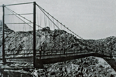
The bridge built at the Upper Narrows was a metal suspension bridge, intended to solve the failures of earlier wooden spans. As completion neared, civil engineer A. H. Koebig warned that it would not meet the contract requirement of 1,250 pounds per lineal foot.To silence critics, the county staged a live load test on September 26, 1890. Under light rain and before a large crowd, a rock-loaded wagon pulled by six mules crossed successfully. It crossed again, now coupled to a second loaded wagon. As the two wagons waited on the east side, a third entered the bridge.
Before it reached them, a suspension-cable support failed. With a roar like a clap of thunder, the anchorage collapsed, dropping men, wagons, mules, and stone 50 feet to the riverbed below. Miraculously, all six people survived. A young boy, Austin Ellis, suffered a leg broken in three places and displayed the stoicism long associated with desert life. Contemporary reports conflict on whether the mules survived; eyewitnesses later confirmed they did not.
Newspapers dubbed the event The Victor Horror.
Rebuilding and Fire
Despite public outrage, the bridge was rebuilt in 1891 by Phelps Manufacturing Company of San Francisco. This second-generation bridge served for about a decade. In 1901, its wooden roadway caught firealmost certainly from a passing traindestroying the deck but leaving the main structure intact. Repairs were made, and the crossing continued in use.Steel, Railroads, and Permanence
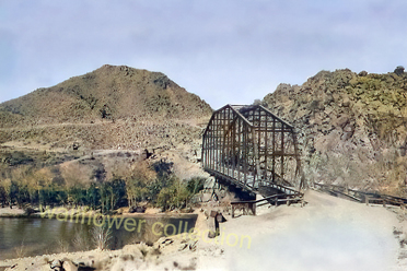
By the early twentieth century, steel technology improved bridge longevity. A steel truss bridge completed in 1916 marked a turning point, accommodating automobiles and stabilizing regional travel. Meanwhile, the Atchison, Topeka and Santa Fe Railway expanded through the Narrows, adding multiple tracks by the 1920s and cementing the areas role as a transportation corridor.The Rainbow Bridge (19281963)
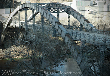
In 1928, the third Victor Bridge was replaced by the graceful Rainbow Bridge, named for its arched profile. For decades it carried highway traffic and became a local landmark, overlooking a stretch of river that alternated between dry sand and flowing water. It remains standing today beside Highway 18, no longer in use but preserved as a visible reminder of earlier engineering.Modern Crossings
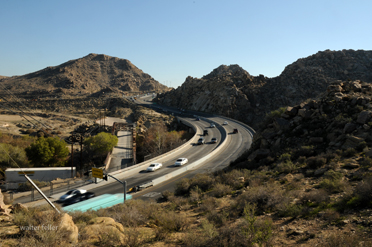
In 1963, a new concrete bridge replaced the Rainbow Bridge as the primary Upper Narrows crossing. Designed to withstand floods and heavy traffic, it reflects the hard lessons learned from seventy years of failure, rebuilding, fire, and collapse. Today, Highway 18 continues to link Victorville and Apple Valley across the Narrows, while Route 66 lies just beyond Old Town Victorville.Legacy
The bridges of the Mojave River Narrows are clear evidence of persistence earned the old wayby trial, error, and respect for the land. From fords to failed suspension cables, from fire-damaged decks to steel and concrete spans, each bridge was shaped by what came before it. The Mojave River never changed its nature; the builders did.Timeline
Late 1890 Public outrage and newspaper condemnation follow. Two supervisors vote to permit reconstruction.1891
Second-generation Victor Bridge completed by Phelps Manufacturing Company of San Francisco.1901
Wooden roadway deck burns, likely from a passing train. Main structure survives; repairs completed for less than $4,000.1916
Steel truss bridge constructed, reflecting advances in engineering and the rise of automobile traffic. Strengthens regional travel centered on Victorville.1920s
Rail infrastructure expands through the Narrows; a second track is laid by 1924.1928
The steel truss bridge is replaced by the arched Rainbow Bridge, named for its bow-shaped profile.19281963
Rainbow Bridge carries highway traffic at the Upper Narrows.1963
Modern concrete Upper Mojave Narrows Bridge replaces the Rainbow Bridge as the primary crossing. The Rainbow Bridge remains standing beside Highway 18, closed to traffic.Present
The Highway 18 bridge continues to connect Victorville and Apple Valley.Earlier bridges remain as physical evidence of more than a century of adaptation to the Mojave Rivers behavior.
These bridges at the Mojave River Narrows represent both the rich history of Victorville today and the one continuing to grow as a transportation hub. They serve as a testament to the dicey situations that early settlers and travelers had to put up with while crossing the unpredictable Mojave River and the stride in infrastructural development that has taken place to date, making it possible for the region to prosper.