The Ridge Route
The Historic Ridge Route near the Grapevine, built between 1915-1919, was the first direct road connecting Los Angeles and Bakersfield. This engineering marvel with numerous hairpin turns facilitated economic growth by linking Southern and Central California. It was eventually replaced by modern highways like U.S. Route 99 and Interstate 5. Today, preserved segments offer scenic drives and historical insights, with markers detailing its significance. The Grapevine area, known for its steep grades and the Tejon Pass, remains a critical transportation corridor. This route highlights the early 20th-century transportation advancements and their enduring impact on California.
A history of the Old Ridge Route was produced by Henry Hill in 1954 for his master's thesis at Occidental College. Excerpts from that thesis follow:
The Ridge Route since its inception, has been the most traveled highways ever built. The route has evolved from a well beaten path in the late 1700's to a dirt road in the mid 1800's to a paved highway in the early 1900's to an 8-lane super highway in the 1970's.
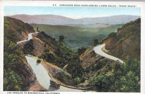
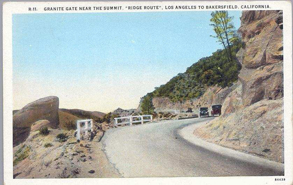
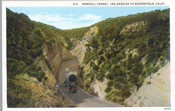
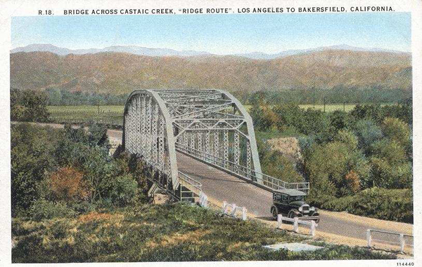
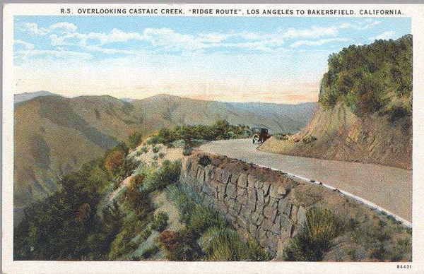
The presently used highway is called the Ridge Route for convenience. The true ridge route which followed the ridges instead of the canyons was built in 1915. The Ridge Route is defined as that section of the U.S. Highway 99 winding over the Tehachapi Mountains between the Castaic cut-off in the south, L.A. county, and extending northward to the bottom of the Grapevine Grade in Kern county, a distance of approximately 40 miles.
Don Pedro Fages, a Spanish military governor, in 1772, was the first white man to enter the southern San Joaquin Valley. He entered from the south probably through Canada de las Uvas, Grapevine Canyon, via Tejon Pass (Tejon is Spanish for badger), the pass of Buena Vista (good view).
Fages reported, "The plain of San Francisco extends from the mouth of the (San Joaquin) river to a village called Buena Vista near the Portezuelo de Cortez, where there are many grapevines; it is about one hundred and sixty leagues long and from twenty to thirty leagues wide. (league=2.63 miles) In it there are numerous weed patches and ponds, and it is very fertile." "From the camp of the Return or of Bad Water (a great valley) extends a village called Buena Vista. . . . It is all a labyrinth of lakes and tulares, and the River San Francisco (San Joaquin River), divided into several branches, winding in the middle of the plain, now enters and flows out of the lakes until very near the place where it empties into the estuary of the river. In the midst of the winding of the river on all sides there ware large rises of good soil where, with ease, irrigating ditches could be made."
Little other Spanish exploration occurred. In 1821, California became part of Mexico.
...
In 1827, Jedediah Strong Smith led a expedition interested in beaver fur trapping, across the Mojave desert, through the Cajon Pass to the San Gabriel Mission. Without permission, the group moved north and entered the valley through the Tejon or Tehachapi Passes.
In 1829, Ewing Young expedition with Kit Carson entered the valley through the Tejon Pass.
By 1840, the Spanish dons sent their great herds to graze in the Tejon and Buena Vista regions. The first land grant awarded in the San Joaquin Valley was issued in 1842 for over 17,000 acres.
By 1850 the fur trappers were gone and the gold rush was on. Probably the most famous of all California outlaws, Joaquin Murietta was killed near Tejon Pass by a party of rangers led by Captain Harry Love.
In 1853, the U. S. Government, the U. S. Topographical Engineers sent Lieutenant R. W. Williamson to investigate the possibility of a railroad route over the mountains. Williamson become so disgusted with the original Tejon canyon trail that he scouted Canada de las Uvas to the west, which he later recommended to his superiors as the best possible approach to the San Joaquin Valley from the Los Angeles basin.
Edward Fitzgerald Beale, army general, and recent promoter of the new federal Indian reservation policy, presented to his superiors, the suggestion of a camel corps somewhere in the west. He obtained his idea from travels in Asia and Africa. He convinced Secretary of War, Jefferson Davis, his idea was valid and Fort Tejon was a selected post for the project. $30,000 was allocated for the cost of the camels which were trained by two Greeks and a Turk. The camels went to L.A. for provisions every six weeks. The rocky slopes literally tore the flat, padded feet of the camels to shreds. many camels were allowed to escape from the army posts where they were herded, and many died from pure neglect.
Later in his life, Beale as the surveyor-general of California and Nevada, was called upon to survey the stage route through the Tehachapis, and for this work he was rewarded with a huge piece of Kern County territory of about 300,000 acres.
After the establishment of the fort merchants and ranchers who were enlarging their holdings around the fort raised a clamor for a decent road into the Tejon region. The first road from L.A. was a horse trail. The worst section to cross was the over San Fernando Hill into the Los Angeles Basin. Gabe Allen for $3000 was contracted by L. A. County supervisors to build a usable freight road. In 1855, the new road was opened. Horses had to be led down the steepest parts of the hill, mishaps and accidents were accepted as the order of the day.
Today, cars travel the Ridge Route in less than two hours. The average horseman in 1856 required three days to complete the crossing.
The Butterfield stage route was established in 1858. After stops at Cahuenga and San Fernando Mission, the route continued on northwest for six miles to the entrance of San Fernando Pass or Beale's Cut. Beale was responsible for cutting into the pass to lower the grade for the road. Stage fare was $12 one way from L.A. to Tejon station. Other stations were Hart's Ranch, French John's, King's, Mud Springs, Widow Smith's, and Hollandsville. From Hollandsville the mail road followed the bottom of the canyon; and about two and half miles from the station, it passed through the most constricted part of the gorge, when 65 years later the St. Francis Dam was constructed. Curving around the extreme eastern end of Elizabeth Lake, the road headed slightly northeast for about three miles and then passed over another low divide and dropped into the Antelope Valley. From
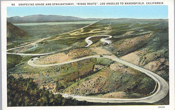
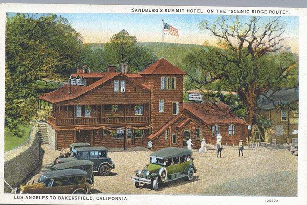
French John's the mail road continued west, along the slopes of the foothills to a point about two and half miles southeast of Quail Lake where Highway 99 make a juncture with the old mail road (Gorman Post Road) to Reed's (Gorman). Reed=s is located 14 miles west of French John=s and 8 miles south of Fort Tejon. Reed had settled on the land at the Gorman location in the early 1850's and built a substantial log house which became a stage station in 1858. From the fort, the road followed a serpentine course down the steep grade through the Grapevine Canyon a descent of some six miles, to the bottom of the alluvial fan where a station was established in 1859. Beale built a turnpike road through his property and into the rapidly developing San Joaquin Valley. The toll costs were 4 cents for one sheep to $2.75 for a team of twelve and a wagon. A horse and man was charged 25 cents.
East bound mails were due on Mondays and Thursdays at 1:00 p.m., west bound mails were due on Mondays and Thursdays at 7:30 a.m. The running time between Tipton, Missouri (end of rail line) and San Francisco, California via Los Angeles and Fort Tejon was 23 days. By 1880's it took 5 days to travel between L.A. and Bakersfield. Private homes and ranches accommodated travelers as they journeyed. The road began in Grapevine Canyon, ran up the slopes to Holland's Summit, across the mountains to Elizabeth Lake, then dropped down into Mint Canyon and Saugus, and finally terminated in the upper San Fernando Valley. Pre-highway travel over the Tehachapis was described in 1907 by Mr. O. R. Kamprath of Bakersfield. A friend of his was the proud possessor of a two cylinder tourist car and wanted to demonstrate it. After 16 hours they arrived in L. A. Up Grapevine Grade, the car stalled about a dozen times and at several places blocks were placed under the wheels with boulders. The remainder of the trip had bumps and ruts, and coming down Bouquet Canyon crossed the creek several times.
By 1910 the economic importance of the Tehachapis and the San Joaquin Valley was receiving a great stimulus because of the discovery of oil. The problem was how to market the black gold. The nation was not yet on wheels. The users of oil were experimental fuel oil ships. The place of delivery was San Pedro. The nearest railroad was 40 miles away. Captain John Barnsson and E. J. de Salba conceived the idea of a pipeline. Forming the General Pipe Line Company, predecessor of the General Petroleum Corporation, and they began surveying the landscape. The pipeline was built from 1912 to 1913, costing $3,300,000 plus $1,000,000 for pumping units to build the pipeline, telephone line, and rugged construction road. The road was not open to the general public. The line delivered 750,000 barrels per month. Standard Oil (Chevron) and Richfield (ARCO) quickly built their own pipelines to the south.
The State Highway Commission had a policy to build state highways by the most direct and practicable routes. The highway over the Tehachapis followed the route of the railroad. Therefore:
1. The new ridge route was chosen as it at 115 miles was 60 miles shorter than the Tehachapi line through the Antelope Valley.
2. The alignments and grades were much easier over the Tejon Pass.
3. The Tejon route better served the western end of the Antelope Valley and the oil district of SW Bakersfield.
4. Drainage was better over the Tejon route. At that time the Antelope Valley between Lancaster and Mojave was a swampy sink in times of bad weather. Wind conditions were severe in the Tehachapis and Mojave.
5. The Tejon Creek crossings were fewer by 30 than on the other route.
6. Shorter route encouraged trade, traffic, and intercommunication between L. A. and the Valley.
7. More population was located in Bakersfield than the eastern Antelope Valley to justify the shorter distance of 60 miles between L. A. and Bakersfield.
8. The Tejon route promoted unity between northern and southern California by lifting the Tehachapi barrier. (Agitation for state division was rife in 1912-1914.) The original grading on the route began on September 22, 1914. 1 million cubic yards of earth were removed at a total cost of $450,000. There were less than 126,000 cars in the state and wide open speed was 35 miles per hour. The route was built to the standards of mountain highways of the time, following the contours of the land in order to save grading costs.
The trailblazer for the route was the Southern California Edison Company, who had laid a power line across the Ridge and had developed a service road. The Edison road had an oiler surface and 3500 curves. Construction started in the middle and the highway department cut many of the curves and reduced the grade to 6% sometimes 7% grade. All water, supplies, and building materials had to be hauled great distances. Labor costs were $3.50 to $6.00 a day, commissary charges were $1.00 a day. The biggest difficulty was flash floods. In March, 1914, a cloudburst rendered the original route through Grapevine Canyon impractical as it completely destroyed all previous construction. It was then deemed necessary to locate the line higher up the hillside and control of Grapevine Creek became mandatory.
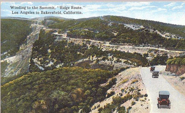
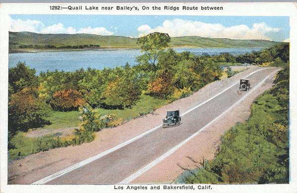
By October, 1915 the unpaved $3,000,000 road was open to the public. It became immediately popular. For a distance of 29 miles the state highway followed the Ridge, winding from one side to the other through the saddles, but keeping substantially the elevation attained. After passing Liebre Mountain, the road descended to Bailey's Ranch, then followed the old route to the San Joaquin Valley.
After three years it was announced in 1918 that, in order to increase efficiency and reduce traffic hazards, the Ridge Route between Los Angeles and Bakersfield was to be paved. Work was started in the Castaic Wash. The Ridge was reinforced with twisted iron bars, laid transversely 18 inches with twisted iron bars, laid edge with rods laid lengthwise. The concrete was 4 and half inches in thickness. The curves were banked whenever necessary with at times substantial concrete curbs 6 inches wide and 10 inches high at all the dangerous points added to the safety of the road and assisted in the drainage problems. On opening day, November 15, 1919, L.A. County installed two patrolmen to enforce the 15 m.p.h. speed limit. Traveling on the wrong side of the road was considered a lessor offense.
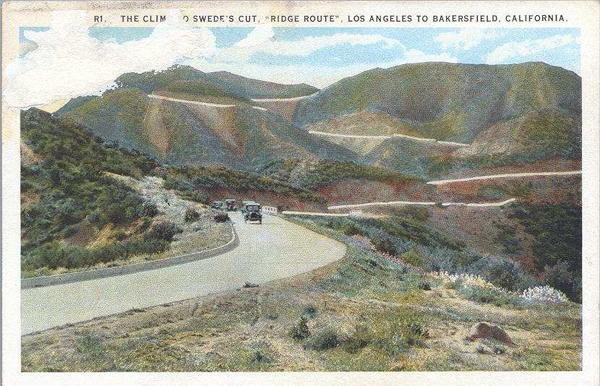
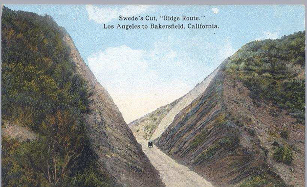
By 1920 the entire road was paved. The original Ridge Route was one of the most nerve-racking, perilous, and costly roads ever built. 32 persons maybe more were killed from 1921 to 1928. In only 36 miles there were 697 curves, with a maximum radius of 70 feet. Added up, the turns driven were 97 complete circles between Gorman and Castaic. Blind curves were the other problem, somewhat improved by partial daylighting of the worst curves. The American Automobile Association estimated that drivers made 1500 to 1800 brake applications on the average trip over the ridge and brake linings good for 15,000 miles were good for 4,000 miles over this highway. Continuous improvements were made until the new highway was built in 1933.
from; OLD RIDGE ROUTE - SAN FRANCISQUITO CANYON-SAN ANDREAS FAULT: FIELD GUIDE: 2000 EDITION
by: GREGG WILKERSON
file:///C:/digital-desert/ridge-route/OLD_RIDGE_ROUTE_SAN_FRANCISQUITO_CANYON.pdf
The Historic Ridge Route, particularly near the Grapevine, is a fascinating piece of California's transportation history. This winding mountain road, constructed in the early 20th century, served as the first direct route between Los Angeles and Bakersfield, crossing the Tehachapi Mountains. Here are some key points about it:
History
Construction:
Built between 1915 and 1919, the Ridge Route was designed to connect Southern and Central California, overcoming the difficult terrain of the Tejon Pass.Engineering Feat:
The road featured numerous hairpin turns and was a marvel of early 20th-century engineering, allowing vehicles to traverse the steep grades.Economic Impact:
It played a crucial role in economic development by facilitating the movement of goods and people between the two regions.Decline and Preservation
Superseded:
By the late 1930s, the Ridge Route had been largely replaced by more modern highways, such as U.S. Route 99 and later Interstate 5, which offered faster and safer travel.Historic Status:
In recognition of its historical significance, portions of the Ridge Route have been preserved and designated as a National Register of Historic Places site.Visiting Today
Scenic Drives:
The remaining segments of the Ridge Route offer a scenic drive through a landscape rich in history, with many original features still visible.Historic Markers:
Visitors can find historic markers and interpretive signs that provide insights into the road's construction and significance.Challenges:
Parts of the road can be rough and are best suited for vehicles with good clearance. Check current road conditions before visiting.Grapevine Area
Grapevine Canyon:
Known for its steep grades, this area was particularly challenging for early motorists and remains a critical transportation corridor today.Tejon Pass:
Often referred to as "The Grapevine," the pass is a key route through the Tehachapi Mountains and features dramatic elevation changes.The Historic Ridge Route near the Grapevine is a testament to the ingenuity and determination of early road builders and offers a unique glimpse into the past for those interested in California's transportation history.