Mountain Springs Pass

Old Spanish Trail and the Salt Lake Road are best understood as two different routes serving different needs, even when they share some of the same ground.
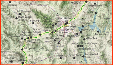
The Old Spanish Trail was primarily a mule-pack trade route linking Santa Fe and Los Angeles, used most heavily in the 1830s and 1840s. It was built around what pack animals required: reliable water, forage, and workable day-to-day travel across long dry stretches. In the Las Vegas region, the routes practical logic shows up clearly at Mountain Springs Pass: a mountain gateway segment supported by springs and grass, with travel commonly broken at Cottonwood Springs (Blue Diamond) to make the climb feasible within a day.
The Salt Lake Road (often called the Mormon Road or Los AngelesSalt Lake Road) developed later, starting with Mormon travel after 1847 and strengthening in the 1850s as a wagon-capable freight and travel road between Utah and Southern California. Its job was different: moving wagons, freight, and people on a dependable corridor, often valued for being practical in winter compared with higher, snowbound routes. Because wagons have different limits than pack trains, the Salt Lake Road tends to favor gentler grades, wider passages, and more regular stopping patterns, and it often formalized stations and improvements over time.
Where they overlap, like the Las Vegas oasis node and the Mountain Springs gateway, its usually because the landscape forces the same sensible choice: water first, then the best pass. In other words, shared segments are less about one trail becoming the other and more about both routes recognizing the same corridor truth on the ground.
Las Vegas and Mountain Springs Pass. The trip was broken at Cottonwood Springs, the site of Blue Diamond, where an early start was usually made in order to climb the pass by nightfall. Early travelers often referred to the area as Paiute Springs, but the present title has been used for over a century. The altitude made Mountain Springs one of the favorite camping spots on the Trail."