Ubebehe Craters
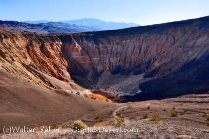
The Ubehebe Craters consist of an isolated group of overlapping maars formed during eruptions of alkali basalt along a fault cutting fanglomerate deposits on the flanks of Tin Mountain in Death Valley National Park. Ubehebe Crater is a 0.8-km-wide, 235-m-deep maar surrounded by a tuff ring. Little Hebe Crater, the second youngest vent, is located immediately south of Ubehebe Crater and is a small tuff cone with a 100-m-wide crater overlain by pyroclastic-surge deposits. At least a dozen craters are located within an area of 3 sq km, and bedded pyroclastic-surge deposits cover an area of 15 sq km. Early scoria cone formation was followed by hydrovolcanic explosions that formed two clusters of explosion craters and tuff rings. The age of volcanism at Ubehebe is not dated precisely, but the lack of erosional modification of pyroclastic-surge deposits suggests that the youngest activity, from the largest crater, Ubehebe Crater, is Holocene in age. Relationships between Ubehebe tephra and approximately dated archeological artifacts suggests an age of about 6000 years.Ubehebe craters are an isolated group of maar volcanoes erupted through nonvolcanic sediments of Death Valley National Park. The craters were formed by hydrovolcanic explosions along a fault. The contact between pre-eruption yellowish- and orange-colored sedimentary rocks and overlying black ash deposits from an early stage scoria cone can be seen at the upper part of the western wall of 800-m wide, 235-m deep Ubehebe crater, the youngest and largest crater.
Country: United States
Subregion Name: California (USA)
Volcano Number: 1203-16-
Volcano Type: Maars
Volcano Status: Anthropology
Last Known Eruption: 4050 BC (?)
Summit Elevation: 752 m 2,467 feet
Latitude: 37.02°N 37°1'0"N
Longitude: 117.45°W 117°27'0"W
Scotty's Castle Area - Ubehebe Crater
Maar volcanoes formed by steam and gas explosions around 3,000 years ago created when hot magma reached ...
Death Valley Geology - Ubehebe Crater
At the edge of Ubehebe Crater, you'll be greeted by an eerie, surreal landscape. All is quiet now, but imagine yourself transported to a time just ...
Death Valley Geology Field Guide - Ubehebe Crater
The geology of Ubehebe Crater, Cottonwood Mountains, Death Valley regional field guide.
Death Valley Geology
Yesterday's Volcano - Recent signs of volcanic activity exist in northern Death Valley at Ubehebe Crater. Caused by violent ...
Ubehebe Crater Aerial/Satellite Photo Overlay