Cooke & Graham
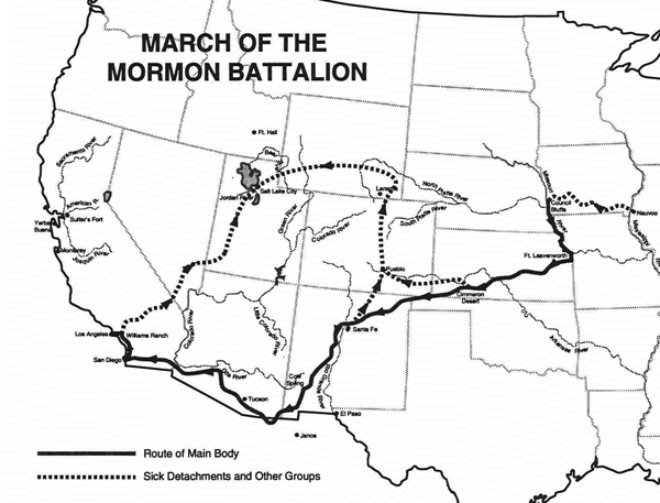
Determined to take the wagons through, Cooke and the Mormon Battalion pioneered a road into southwestern New Mexico near the copper mines and across the continental divide in the vicinity of Guadalupe Pass. Striking the San Pedro River, the battalion turned northward along its course, left it to march westward to Tucson, thence northward again to the Gila. From that point, Cooke followed Kearny's trail to San Diego, arriving there in late January 1847. Neither Kearny nor Cooke had plunged blindly into unknown southwestern wilds. General Kearny had recognized early in his plans for the conquest that American trappers could make an invaluable contribution to the struggle. Among a number of mountain men, some unnamed, who accompanied Kearny's force as guides and interpreters were Kit Carson, Thomas "Broken Hand" Fitzpatrick, and Antoine Robidoux. Guiding the Mormon Battalion were Antoine Leroux, Pauline (Powell) Weaver, and Jean Baptiste Charbonneau. Most had trapped New Mexico streams.
Brigham Young University
Cooke's route was shortly improved. In 1848, following the end of the war with Mexico, Major Lawrence P. Graham led a battalion of United States Army dragoons from Chihuahua to California. Marching through Janos, Graham struck Cooke's road. Beyond the continental divide, however, Graham left Cooke's route at the San Pedro River and continued westward to the Santa Cruz river before turning north to rejoin Cooke's road to Tucson. In later years, argonauts and emigrants arrived at Janos from many directions, but most of them then followed Graham's route to California, that is, Cooke's road as modified by Graham's detour to the Santa Cruz river.
Cooke and Graham may share the credit for establishing the route, but it is worth noting that Father Garces thought of it first. Graham's trail all the way from Chihuahua to the Colorado is precisely the route suggested by Garces in 1777 for the purpose of supplying proposed missions on the Gila and Colorado Rivers.
Previous - Next