White Cap Mountain
CM3. Location/Access:(36o 48.250N; 117o 24.350W) White Cap Mountain, also called White Top Mountain is located 33 miles south of Ubehebe Crater via a series of gravel roads that require high clearance and usually four-wheel-drive. From Ubehebe Crater, continue south to Teakettle Junction as if you were going to the Racetrack. However, at Teakettle Junction, turn left and continue through Lost Burro gap. At 3.2 miles you will come to a four-way junction. The road to the right leads to the Lost Burro gold mine (worth a visit) and the road ahead leads to Hunter Mountain (Site CM4) and the road to the left leads 9.8 miles to a spectacular viewpoint just north of White Cap Mountain. This last stretch of road is usually quite passable and smooth as it is above the fan gravels. Once near the pinyon woodland, there may be a few rough spots. The very last few hundred yards is very steep, very rough and requires four-wheel-drive. We often walk this last little stretch. Much of this road may be blocked by snow in mid-winter. The viewpoint is actually some distance north of White Cap Mountain proper.
Best Time: Mid- to late afternoon.
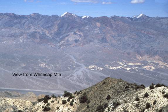
Geology: This is one of four places in this guide that offer a great view of Death Valley. When you make the left turn at Lost Burro Junction, you are at the north end of Hidden Valley which is a bolson. The view on the way up from here includes views of the Stovepipe Wells area. At the top, the view towards the Grapevine Mountains is very impressive. The massive folding, the colorful Paleozoic sediments and the fans and bajadas of northern Death Valley are all visible. The view to the west is blocked by higher mountains. En route to the summit you will pass through Ordovician, Devonian and Mississippian age sedimentary rocks, mostly shale and limestone. These rocks are much younger than the pre-Tertiary rocks that dominate in the central and southern parts of Death Valley. At the summit some unusual Mesozoic plutonic rocks with beautiful feldspar crystals form the road cuts near the point. Many of the formations seen en route are quite fossiliferous. In Lost Burro Gap, we have found articulated brachiopods in the brown beds at road level on the northeast canyon wall and just when you enter the canyon en route to Rest Spring and the summit, there are ammonites, graptolites and crinoids in the limestone layers above the tan layers in the north wall. Remember that fossils may NOT be removed from the national park. At the summit (at our last visit in 2007 anyhow), there is a remote seismic sensing station and a continuous GPS remote station as well.
=-=