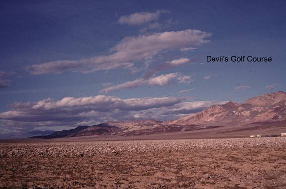
Devils Golf Course
BW5. Location/Access:(36o 17.150N, 116o 49.574W) The Devils Golf Course is located in the center of the Death Valley playa 13.1 miles south of Furnace Creek. The last 1.3 miles is over a level well-graded gravel road. On rare occasions, the road may be closed if the playa is flooded.
Best Time: Late afternoon, all year.
Geology: The Devils Golf Course is the best place to examine the salt pan or playa surface that makes up the floor of Death Valley. The floor of the valley is not truly flat and is actually composed of three very shallow basins. The lowest and southernmost area of the valley floor is the Badwater Basin. This site is at the northern edge of this basin. Any playa, or desert dry lake bed, is composed of the material that have weathered out of and washed down from the surrounding mountains. If the surrounding mountains are composed of granite or other rocks that breakdown by chemical and physical weathering into quartz, clays and other materials, the playa is usually covered with a hardened mud (clay). If the surrounding area is composed of material that weather chemically by solution, then the playa is covered with halite (rock salt) and other evaporates. The playa in Death Valley is a mixture of both. At this particular location, the evaporate materials dominate because the Pliocene Furnace Creek formation (the yellow rocks to the northwest) are a major source of borates and other evaporate minerals. Many studies have attempted to determine over the years exactly how thick these playa deposits are. As Death Valley has dropped over the past 20 million years, various basins have formed and filled with sediment. The current valley in this area has at least 2,000ft of sedimentary deposits composed of fan gravels, silt, mud and evaporate minerals (Hunt, 1976 and others). Since this area is lowest land around, it serves as a local base level for all water. Thus it is no surprise that a large variety of fine materials ends up mixed on the playa. Erosion of these deposits by wind and wind mixed with rain has produced some wonderful small-scale erosional towers and surfaces.
=-=