Digital-Desert : Mojave Desert Photography by
Walter Feller

Visit us on Facebook
features - ecology: wildlife - plants - geography: places - region map - map/sat - roads & trails: route 66 - old west - communities - miscellaneous
ghost towns - gold mines - parks & ...: joshua tree - death valley - mojave preserve - wilderness - native culture - history - geology: natural features - glossary - comments

Wilderness - MAP
Funeral Mountains >> Map #64

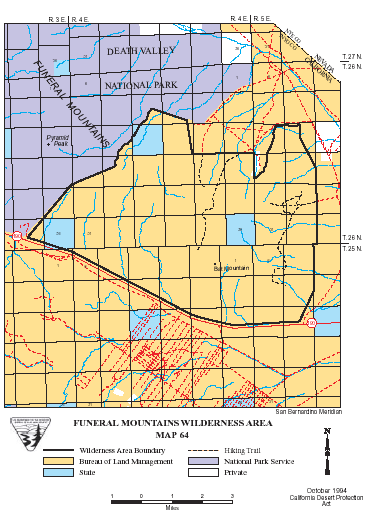
Funeral Mountains Wilderness

SIZE: 28,110 acres

LOCATION: Inyo County; 3 miles northwest of Death Valley Junction, California

NATURAL RESOURCES: Amargosa Desert alluvial slopes ascend into the Funeral Mountains. Rugged and colorful bands of limestone rock lay to rest any images conjured up by the Funeral Mountains, for which this wilderness area is named. Elevations range from 2,200 feet and rise 4,950 feet to the summit of Bat Mountain. Capped at nearly 7,000 feet, Pyramid Peak and the western boundary of this wilderness lie within Death Valley National Park. Desert bighorn sheep have been seen near these peaks.

GLOSSARY > alluvial fan, limestone

ACCESS: Access this wilderness area from State Highway 127 or 190.


Eclipse Art Gallery

Two Sisters Rock Shop


features - ecology: wildlife - plants - geography: places - region map - map/sat - roads & trails: route 66 - old west - communities - miscellaneous
ghost towns - gold mines - parks & ...: joshua tree - death valley - mojave preserve - wilderness - native culture - history - geology: natural features - glossary - comments
Country Life Realty
Mountain Homes and Real Estate for Sale

~ Wickless Candles by Scentsy ~
The Most Wonderful Time of the Year ...
... Is here
MH Sleds
Saucer sleds for the snow
Life time guarantee!!!

Abraxas Engineering
privacy
Copyright ©Walter Feller. All rights reserved.