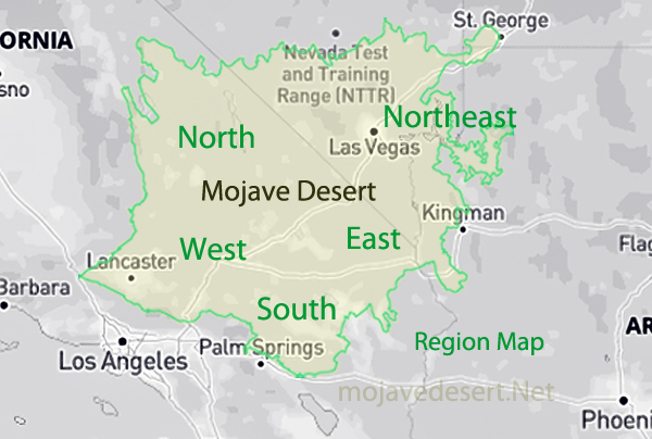
Mojave Desert Regional Map
Geography
It is the study of Earth's physical features, how humans interact with these spaces, and how cultures and biological systems fit into the landscape. Everything from mountains and rivers to cities and countries falls under this category. When referring to geography, one is often considering not just what is on the surface, but how all these features connect and influence each other.The five themes of geography-Location, Place, Human-Environment Interaction, Movement, and Region-help break down the study into manageable pieces. Location tells you where something is; Place describes what that area is like; Human-Environment Interaction looks at how people and nature affect each other; Movement studies how goods, people, and ideas get around; and Region groups places with similar characteristics.
These geographical factors, coupled with the Mojave Desert, delineate subregions including: the Southern, Western, Northern, North-Eastern, and Eastern Mojave. This vast desert covers parts of Southern California, Utah, Nevada, and Arizona-all playing a major influence in everything from wildlife to routes of transportation. Being able to understand the positioning of these sub-regions means gaining a better understanding of not only the Mojave's ecological history but also its human history regarding Native American historic homelands, geomorphic provinces, or the various ecological zones across the state of California.
Southern Mojave
Western Mojave
Northern Mojave
North-Eastern Mojave
Eastern Mojave
The Mojave Desert occupies a significant portion of Southern California and parts of Utah, Nevada, and Arizona:
Freeways and Highways Map
-
Interactive map of major transportation corridors in the Mojave Desert