Digital-Desert : Mojave Desert Visit us on Facebook -- Desert Gazette -- Desert Link
Intro:: Nature:: Map:: Points of Interest:: Roads & Trails:: People & History:: Ghosts & Gold:: Communities:: BLOG:: Weather:: :?:: glossary
OST/Salt Lake Road

Stump Springs


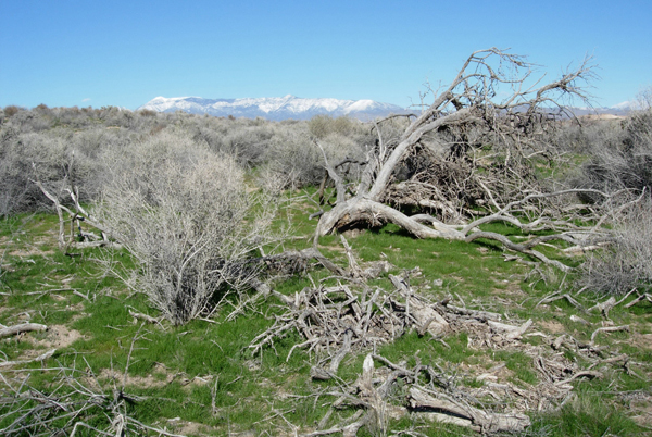
Stump Springs - BLM photo
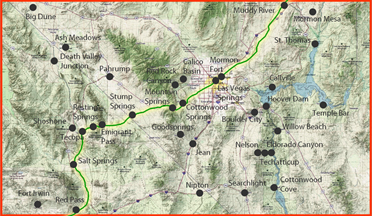
Physiographic Description

The Stump Spring ACEC is in Pahrump Valley, which is separated by the Spring Mountains from Las Vegas Valley to the east. The west boundary of the Pahrump Valley is formed by the Nopah and Kingston Ranges. The valley is relatively flat and as much as 25 km wide. The ACEC ranges from about 780 to 850 meters in elevation and contains a small intermittent stream that drains southwest. The ACEC is named for Stump Spring, which was used by early travelers through the area.

Geologic Setting

Pahrump Valley is on the southwest margin of the Basin and Range Physiographic Province. The region has experienced multiple periods of deformation, including Mesozoic compression followed by extension that began in Miocene time. The State Line Fault Zone, a zone of strike-slip faulting that strikes almost parallel to the Nevada-California border in the center of the valley, is within the Walker Lane belt, a major northwest zone of right-lateral faulting caused by late Tertiary to modern extension (Stewart, 1992). Analysis of gravity data indicates that the valley could have formed as a pullapart, transtensional structure along the State Line Fault Zone (Blakely and others, 1998).

The mountains bordering the Pahrump Valley are mostly composed of Late Proterozoic and Paleozoic carbonate and siliciclastic rocks, which probably also underlie the valley. The subsurface bedrock of Pahrump Valley is deformed and topographically complex (Blakely and others, 1998); it is covered by sedimentary deposits that are Oligocene and younger in age. These include Quaternary playa deposits and large alluvial fans on the northeast side of the valley (Sweetkind and others, 2003).


from: Chapter K. Mineral Resource Potential of the Stump Spring Area of Critical Environmental Concern, Clark County, Nevada
By Kathryn S. Flynn, Steve Ludington, Brett T. McLaurin, and Stephen B. Castor


Stump Springs is another notable site along the Old Spanish Trail, a historic route that linked Santa Fe, New Mexico, with Los Angeles, California. This trail, renowned for its challenging and varied landscapes, included segments that traversed through some of the most arduous terrains of the American West.

Stump Springs, located in what is now the Mojave Desert, served as a critical water source and rest stop for travelers on the Old Spanish Trail. In the vast and arid desert environment, where water was scarce and the conditions were harsh, places like Stump Springs were invaluable for the survival and well-being of both people and animals on the trail.

The Old Spanish Trail was extensively used in the 19th century, primarily for trade purposes. It was an important route for the movement of goods, particularly horses, mules, and woolen textiles. The trail also facilitated exploration and the westward movement of settlers.

At Stump Springs, travelers would have had the opportunity to replenish their water supplies, rest, and possibly graze their animals. The presence of such springs along the trail was vital, as they offered necessary relief and resources in the desert. The journey across the Old Spanish Trail was fraught with challenges, including extreme weather conditions, rough terrain, and the potential for conflicts with Native American tribes.

In the present day, Stump Springs and other similar sites along the Old Spanish Trail are recognized for their historical importance. These locations offer a window into the past, revealing the resilience and resourcefulness of those who traversed this legendary route. They underscore the significance of natural resources like water in the history of exploration and settlement in the American West.

Intro:: Nature:: Map:: Points of Interest:: Roads & Trails:: People & History:: Ghosts & Gold:: Communities:: BLOG:: Weather:: :?:: glossary
Country Life Realty
Wrightwood, Ca.
Mountain Hardware
Wrightwood, Ca.
Canyon Cartography
DesertLink
Links to Desert Museums

Grizzly Cafe
Family Dining


Custom Search

AbeBooks
Abraxas Engineering
privacy
These items are historical in scope and are intended for educational purposes only; they are not meant as an aid for travel planning.
Copyright ©Walter Feller. 1995-2023 - All rights reserved.