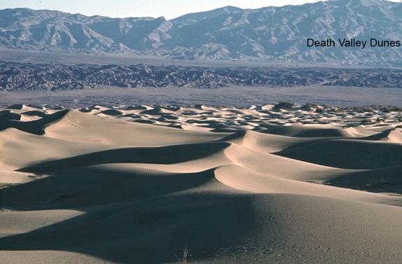
Stovepipe Wells Sand Dune Field
NP1. Location/Access:(36o 36.292N, 117o 06.436W) Located a mile or so east of the village of Stovepipe Wells. Park anywhere directly along CA 190.
Best Time: Early morning or late afternoon, the air is clearer in winter.
Geology: This is the largest sand dune field in Death Valley National Park. It is also called the Death Valley dune field and Mesquite Dunes. There are other dune fields located near Saratoga Springs (Site FS1), Eureka Valley (Site FN4) and in the northern Panamint Valley. These dunes are generally transverse dunes with maximum heights of about 180 feet and with axes trending roughly southeast-northwest (Spear, 1986). Since the steep face of the dunes is on the south side of most of the ridges, the prevailing dune-shaping winds must come from the north. However, the local wind pattern is obviously more complex because just east of the dunes is the Devils Cornfield, an area of deflation with arrow-weed shocks holding sand and clay within exposed upper root structures. Thus the wind is both eroding and depositing within a very short distance. Since the wind obviously blows from the north most of the time and the huge mass of Tucki Mountain lies directly south, one can infer that Tucki Mountain blocks the flow of wind and as the north wind sloughs off to the east as it heads southward past the east slopes of Tucki Mountain, increased velocity causes erosion just east of the dune field in the Devils Cornfield. The source of the sand is both local fan and bajada surfaces as well as from Death Valley Wash, the main drainage of northern Death Valley which terminates (except during very high runoff) just north of the dune field. The dunes are estimated to be only about 2,000 years old and the alluvial fill upon which they sit is the deepest in Death Valley, nearly 5-7km thick (Klinger and Sarna-Wojcicki, 2001). While many people often think of deserts as being full of sand, dunes only cover about 2.3% of the land area of Death Valley (Spear, 1986), which is not inconsistent with data for the American deserts as a whole. For more on the dunes, please see Sharp and Glasner (1997). From the dunes, one can look southward toward Tucki Mountain and see a rather dramatic sequence of tilted of generally east-dipping sedimentary rocks. On the left flank are mid-Paleozoic rocks and as you look towards the west the sequence goes to Ordovician, Cambrian, upper Proterozoic (Precambrian including the Noonday formation) and then the Pahrump group. The exposure and the domal shape of Tucki Mountain are due to movement along the Tucki Mountain detachment which lies on the west side of the mountain (Wernicke, et. Al., 1993, especially the map on p. 459).
=-=