Chloride Cliff
GF1. Location/Access:(36o 41.692N, 116o 52.807W) Chloride Cliff can be accessed one of two ways off of the Beatty Road. The shortest (but far rougher) way leaves from Site CD5b. A dirt road leads up the canyon 5.2 miles to a junction. The first half of this stretch can be done with high clearance but the second half requires four-wheel-drive. At the junction, turn right and continue up the hill. It is during this steep climb that you will need four-wheel-drive again but after the crest, you will not. Continue past the junction for about 2 more miles, keeping left each time you have a choice. You will pass through the abandoned mining camp of Chloride City, which contains the remains of a few buildings and the remains of a miner in a grave near the building fronting one of the main mines. Just before you reach the top, you will have to bear right around a low hill and you will probably have to stop just before the last 100 feet or so because the road is too steep. The longer (but far easier) way, requires that you continue on the Beatty Road after you leave Site CD5b for an additional 7.1 miles (or a total distance of 10.5 miles from the Beatty Cut-Off Road and the Mud Canyon Road. At this point, you will be at the national park boundary in Nevada. Turn right and head southeast for 6.8 miles until you reach a junction coming in from the left and behind you. To this point, the road is often rough, but relatively flat. At this junction, the road becomes much smoother. Continue for 4.1 miles to the junction mentioned above for the short route. Again, you will need four-wheel-drive only for this one rough climb. Continue on, generally keeping left, until you reach the top.
Best Time: Early to mid-morning, all year, but winter is best because the air is clearer.
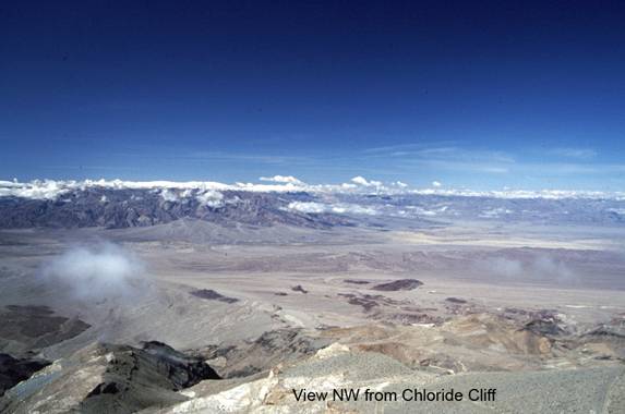
Geology: For a description of the geology en-route on the first half of the shorter, rougher road, please see Miller and Wright (2004, p. 90). On our trips, we always come in the longer way because it is easier on vehicles and the additional dozen miles does not add any time to the trip. The longer route brings you over alluvial fan and wash gravels until just before you reach the junction of the two routes. Within the canyon prior to the junction, you are traveling through the late Proterozoic Stirling quartzite. At the junction (10.9 miles from the highway), you cross the Boundary Canyon detachment and the steep climb up the hill is through the Johnnie formation, across the Chloride Cliff fault then over the Pahrump Group (mostly Kingston Peak formation) to the top (mostly Beck Spring and Crystal Spring). At this point, you are on the footwall of the Boundary Canyon-Chloride fault detachment system. The Chloride fault is visible in the hillside to the east. The view from the top is spectacular and to most people who have visited all four major view points (Sites GF1, NP6, CM3, FC4) on our trips, this is usually the favorite. Southward there is a view down the valley along the Furnace Creek fault zone. The area around Badwater is visible in the distance. The northernmost basin of the Death Valley playa is also clearly visible as are the Panamint Mountains to the west of the village of Furnace Creek. The western view from the summit provides a view of the dunes near Stovepipe Wells, Tucki Mountain, and the ranges to west including the Cottonwoods, Inyos and Sierras. The Lake Manly gravel bar (Site CD3) and the mines in around the Keane Wonder Mine (Site CD4) are in the near foreground. To the north, the folding in the southern Grapevine Mountains is apparent and to the east, the view across western Nevada reveals classic Basin and Range topography as well as a glimpse of the volcanic rocks near Rhyolite, Nevada and the Paleozoic sediments and Tertiary volcanic rocks south and east of Beatty.