Echo Canyon/Arches
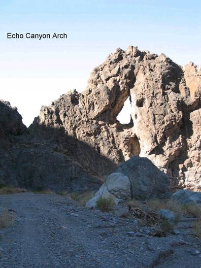
FC1a. Location/Access:(36o 27.820N; 116o 45.916W) The turn-off to Echo Canyon is located 2.1 miles southeast of the junction of CA 190 and the Badwater Road. Turn left, northeast, on the gravel road and continue up the alluvial fan surface. The first arch is located at the GPS coordinates stated above, 4.2 miles from Highway 190. The first portion of this road has deep gravel so four-wheel-drive is advisable. The second, and much larger arch is located 0.5 miles further up the canyon (a total of 4.7 miles from the highway)(at 36o 28.037N; 116o 45.605W). A better view of the larger arch can be seen by continuing a short distance up the road as the canyon bends around behind the arch. A much smaller, third arch is located at 0.6 miles past the larger one (5.3 miles from the highway) at 36o 28.242' N; 116o 45.190' W.
Best Time: Any time of day, avoid mid-summer.
Geology: The first portion of this trip is mapped on McAllister (1970), a useful map for most of the sites in the Furnace Creek Wash area. The route travels over Quaternary fan gravels and then enters Echo Canyon proper. There are some Ordovician rocks and then a long traverse through the Cambrian Bonanza King formation. The arches have been weathered out of the Bonanza King limestone; the larger one at a bend in the wash in the hour-glass portion of the canyon and the smaller ones along sharp ridge crests. Like most desert canyons, Echo Canyon has a dendritic drainage pattern above this narrow section of the drainage and a distributary pattern below, hence the name hour-glass. In the immediate vicinity, check for stromatolites within the limestone and you will notice there are several very small caves high up on the cliffs on the north side of the canyon 0.4 miles past the arch. Other fossils have been reported in the immediate vicinity including trilobite cephalons and oncolites on the north wall within the tan shale underlying the dark gray limestone of the lower Bonanza King Formation. There are also some marvelous dendrites in the shale. This locality is just above the hourglass portion of the canyon and is quite obvious as the canyon opens up here and the tan shale on the north side is markedly different than the dark limestone through which you have been traveling. On our last visit, in October, 2007, we found a rock hammer at this location (36o 28.284' N; 116o 45.190' W). This is a NO-NO. Never collect fossils in a national park. Continue up the canyon to Site FC1b. After 1.2 miles past the third arch, there is a large debris flow on the right.
=-=