Zabriskie Point/20 Mule Team Canyon
FC2. Location/Access:(36o 25.206N; 116o 48.745W) Zabriskie Point is located just off Highway 190, 3.6 miles southeast of the CA 190 junction with the Badwater Road. This is a very popular location and very well marked.
Best Time: Early morning, all year.
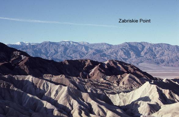
Geology: Zabriskie Point and nearby 20 Mule Team Canyon are the best places to see the upper Miocene-lower Pliocene Furnace Creek formation. The yellow rocks in the foreground as one looks west from the viewing area at the GPS coordinates compose part of the over 5,000ft of lake sediments and underlying other rocks of this formation.
The formation is dominantly composed of mudstone and sandstone with minor amounts of volcanic ash and other rocks and is the major source of borax minerals in the central Death Valley region. Lower members include gypsum, conglomerate and volcanic rocks (McAllister, 1970). The rock unit below this is the Artists Drive formation (Site BW6) which forms the near skyline to the south. The unit above is the Pliocene/Pleistocene Funeral formation which forms the near skyline to the northwest. This is a classic example of badland topography wherein the landscape shows a densely spaced dendritic drainage pattern, intricately eroded hills and practically no vegetation. The lack of vegetation is due both to the alkaline chemistry of the rock and its high clay concentration which inhibits the infiltration of infrequent rain.
Although rain is infrequent here, major floods in 1939, 1941, 1985 and 2004 have caused the highway to be re-aligned and diversion dams to be built (Troxel, 1974; Snyder & Kammer, 2008). After the first flood, Furnace Creek Wash was diverted away from Highway 190 and sent down Gower Gulch to the main valley floor. This drop in base-level has caused a dramatic up-canyon migration of a nickpoint to 20 Mule Team Canyon. In addition to significant channel deepening due to the relative base level drop, numerous other changes to the channels have occurred (Snyder & Kammer, 2008).
Spectacular distance views to the west include
Telescope Peak
and the northern
Panamint Range
with descending
bajadas and the
playa floor. To
the east the
Funeral Mountains
are quite dramatic. Nearby 20 Mule Team Canyon offers an opportunity to closely examine the upper portion of the Furnace Creek formation.
=-=