Digital-Desert : Mojave Desert
Intro:: Nature:: Map:: Parks:: Points of Interest:: Ghosts & Gold:: Communities:: Roads & Trails:: People & History:: Weather:: :?:: glossary
Amargosa River - Amargosa River Photos

Badwater

The water collects for a bit, and then seeps into the alkali of the Badwater Basin.
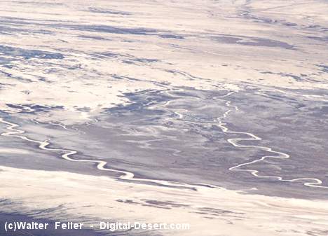
The Amargosa, through a myriad of meanders and sinks, slips beneath the surface and disappears.

< Previous - Next >


Also see:

Badwater

Badwater is the lowest elevation in the western hemisphere you can ...

Badwater Geology

This geographic region--known as "Basin and Range"-- is spreading apart, fracturing the ...

Badwater Regional Geology

These sites can be visited while in transit between Furnace Creek and Shoshone ...


Intro:: Nature:: Map:: Parks:: Points of Interest:: Ghosts & Gold:: Communities:: Roads & Trails:: People & History:: Weather:: :?:: glossary
Country Life Realty
Wrightwood, Ca.
Mountain Hardware
Wrightwood, Ca.
Canyon Cartography
DesertLink
Links to Desert Museums

Grizzly Cafe
Family Dining

Custom Search

Abraxas Engineering
privacy
These items are historical in scope and are intended for educational purposes only; they are not meant as an aid for travel planning.
Copyright ©Walter Feller. 1995-2024 - All rights reserved.
Set 05-08-12 - - 4421