Three Rivers that Do Not Reach the Sea
Three rivers enter upon the vast domain of the Mojave Desert from high mountain ranges, but none delivers any water to the ocean. These are the Mojave, the Owens, and the Amargosa rivers. The rivers originate on high mountain ranges, fed by melting snows that gather upon the high ranges and peaks, and by rains that are condensed from the wind-borne clouds at high altitudes. These all start as rapidly flowing turbulent torrents. They continue for many miles as intermittent streams, but ultimately disappear by evaporation after passing into the porous soils and sands, detritus from the erosion of the mountain slopes. Other streams that flow as mountain torrents to the great desert plain sink at once into the sands and are "lost" as streams.Mojave River
The Mojave is a typical desert river. It rises in the high San Bernardino Mountains, in southwestern San Bernardino County. The waters gather in the mountains and form a perennial stream. Within a short distance it emerges upon the desert plain, and much of the water sinks into the porous alluvium. The course of the stream is in a northerly direction to Barstow, where it turns to the northeast. In times of flood the water may be carried 40 miles east of Daggett to Soda Lake. Water sometimes flows into Silver Lake, another playa a mile or two to the north of Soda Lake. During many years no water from the river reaches the playas, but in years of extreme flood the water may be several feet deep in the playas and remain for several months. The water that reaches the playas disappears by evaporation. The river ends in these depressions. The region of these playas has been called "the Sink of the Mojave."Amargosa River
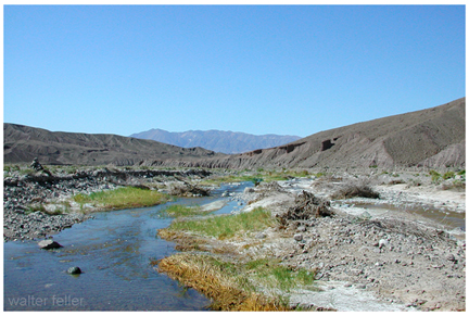
Amargosa River rises in a group of springs about 17 miles northeast of Bullfrog, Nevada. It is dry the greater part of the time throughout much of its course. It is about 140 miles long. Its course is east of south through Franklin Dry Lake, thence south through a canyon about 10 miles long to the southern end of Death Valley. Here it turns westward to Saratoga Springs, where it flows northwestward to the sink of Death Valley. The northern end of Death Valley lies nearly due west of the head of the river, so that the depression which is occupied by the Amargosa River as a whole is in the form of a long and narrow U. Ordinarily there is water at only a few places along the course of the channel, but when a cloud-burst occurs it may become a raging torrent for a few hours. For many years the river has not been known to carry enough water to flow on the surface as far as the lowest depression of Death Valley. The waters of the Amargosa are briny along its lower course. Where it spreads out into the large playa at Resting Springs Dry Lake it leaves fields of salt as well as of borax and niter. Hot springs discharge into it at a number of places.Owens River
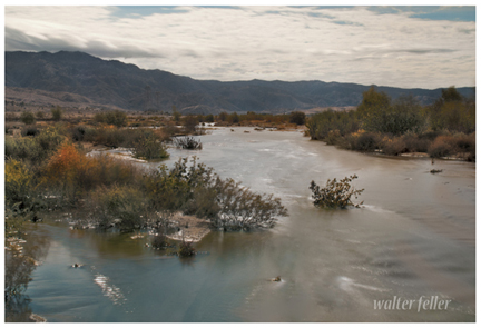
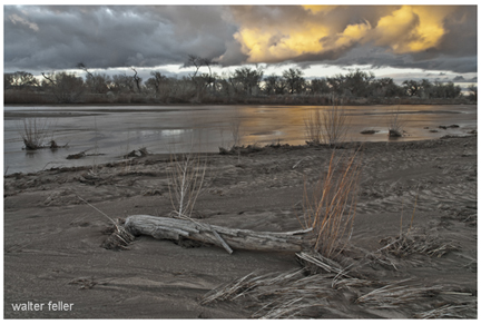
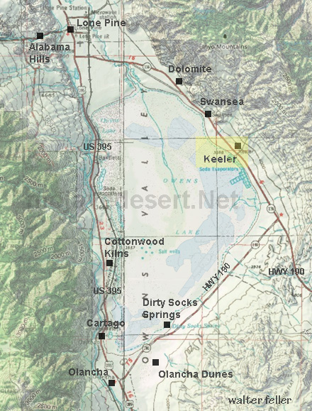
Owens River is the principal stream occuping Owens Valley. Owens Valley is a long narrow depression lying between the Inyo Range on the east and the Sierra Nevada Range on the west. Between these two ranges Owens River flows south to its end in the saline sea called Owens Lake. The valley is thought to have originated as an enclosed and undrained basin through profound faulting of the crust of the earth. The origin of the valley is thought to be similar to that of Death Valley and most of the enclosed undrained areas of the Great Basin. This great structural valley extends from the great bend of Owens River north of Bishop southeast to the southern end of Owens Lake, a distance of 100 miles. It is wholly in Inyo County.Owens River rises in the Sierra Nevada Mountains near San Joaquin Pass and descends the rugged eastern slopes as a turbulent stream. The river emerges from a deep canyon cut in a table-land of volcanic lava north of Bishop and enters upon the level floor of Owens Valley, whence it pursues a meandering course southeastward to Owens Lake. It is one of the few perennial streams of the Great Basin. Owens Lake, into which the river empties, lies in an undrained depression at the south end of the valley, from which the water disappears by evaporation. The waters of the lake constitute a dense brine containing common salt, sodium carbonate, potassium sulphate, borax, and other salts. The recovery of sodium carbonate is an important chemical industry established near Keeler. About 40 miles above the point where the river enters Owens Lake, near Big Pine, the pure mountain water is diverted through the Los Angeles Aqueduct and conveyed to that city.
Fresh Water of Owens River forms Saline Lake
The waters that gather from the mountains to form Owens River are "pure" as surface waters go. Even the pure clear sparkling waters of mountain streams contain some mineral matter dissolved from the rocks. By long continued evaporation from Owens Lake the contained mineral matter becomes concentrated so that the waters of Owens Lake are strongly saline. The river waters diverted by the Los Angeles Aqueduct are essentially pure. The salts now contained in solution in Owens Lake were undoubtedly derived by the slow accumulation and concentration of the river waters entering the basin. In the geologic past Owens Lake overflowed and supplied water to a series of lakes in Indian Wells, Searles, and Panamint valleys. On the bottoms of these lakes deposits occurred consisting principally of clay, with minor amounts of sand and almost no gravel. In most places they include some chemically deposited salts. In a few places these salts are of economic value.
Adapted from: ADVENTURES IN SCENERY
A Popular Reader of California Geology
BY
DANIEL E. WILLARD, A.M.
Fellow American Geographic Society, Fellow A.A.A.S.
THE JAQUES CATTELL PRESS - LANCASTER, PENNSYLVANIA - 1942
Mojave - Hesperia, Ca.
Mojave River - Helendale, Ca.
Amargosa River - Sperry Wash, Ca.
Owens Lake
