Hoover Dam
Frequently Asked Questions -The Colorado River
 The Colorado River rises in the snowcapped
mountains of north central Colorado and zigzags southwest for more than 1,400
miles before reaching the Gulf of California.
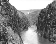
The Colorado River rises in the snowcapped
mountains of north central Colorado and zigzags southwest for more than 1,400
miles before reaching the Gulf of California.
The river and its tributaries - the Green, the Gunnison, the San Juan, the Virgin, the Little Colorado, and the Gila rivers - are called the "Colorado River Basin." These rivers drain 242,000 square miles in the United States, or one-twelfth of the country's continental land area, and 2,000 square miles in Mexico. Seven western states and Mexico have interests in the Colorado River Basin.
What are the seven western states that have interests in the Colorado River?
The Colorado River Basin states are: Arizona, California, Colorado, Nevada, New Mexico, Utah, and Wyoming. Each state is party to the Colorado River Compact entered into in Santa Fe, New Mexico, on November 24, 1922.
How is the Colorado River Basin divided?
The Colorado River Compact divided the Colorado River Basin into the Upper Basin and the Lower Basin. The division point is Lees Ferry, a point in the main stem of the Colorado River about 30 river miles south of the Utah-Arizona boundary. The "Upper Basin" includes those parts of the States of Arizona, Colorado, New Mexico, Utah, and Wyoming within and from which waters naturally drain into the Colorado River system above Lees Ferry, and all parts of these States that are not part of the river's drainage system but may benefit from water diverted from the system above Lees Ferry.
The "Lower Basin" includes those parts of the States of Arizona, California, Nevada, New Mexico, and Utah within and from which waters naturally drain into the Colorado River system below Lees Ferry, and all parts of these States that are not part of the river's drainage system but may benefit from water diverted from the system below Lees Ferry.
How is Colorado River water apportioned?
The Colorado River Compact apportioned to each basin the use of 7,500,000 acre-feet of water per year from the Colorado River system in perpetuity.
How much water is apportioned to each State in the Colorado River Basin?
The Colorado River Compact did not apportion water to any State.
On October 11, 1948, the Upper Basin States entered into the Upper Colorado River Basin Compact, which apportioned use of the Upper Basin waters among them. The compact permits Arizona to use 50,000 acre-feet of water annually from the upper Colorado River system, and apportioned the remaining water to the Upper Basin States in the following percentages: Colorado, 51.75 percent; New Mexico, 11.25 percent; Utah, 23 percent; and Wyoming, 14 percent.
The Lower Basin States of Arizona, California, and Nevada were not able to reach agreement. In 1952, Arizona filed suit in the United States Supreme Court to determine how the waters of the Lower Basin should be divided. In October 1962, the Court ruled that of the first 7,500,000 acre-feet of main stem water in the Lower Basin, California is entitled to 4,400,000 acre-feet, Arizona 2,800,000 acre-feet, and Nevada, 300,000 acre-feet.
The United Stated has contracted with the States of Arizona and Nevada and with various agencies in Arizona and California for the delivery of Colorado River water. These contracts make delivery of the water contingent upon its availability for use in the respective States under the Colorado River Compact and the Boulder Canyon Project Act.
What are Mexico's rights to Colorado River water?
The United States and Mexico entered into a treaty on February 3, 1944, which guarantees Mexico 1,500,000 acre-feet of Colorado River water annually. This entitlement is subject to increase or decrease under circumstances provided for in the treaty.
Source - U.S. Department of the Interior - Bureau of Reclamation
