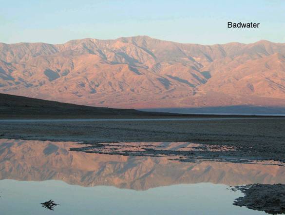
Badwater
BW3. Location/Access:(36o 13.800’N, 116o 46.056’W) 17.4 miles south of Furnace Creek and 30 miles north of Ashford Mill. Badwater is located on all maps, has a wide parking area and is one of the most popular locations in Death Valley.
Best Time: Morning all year.
Geology: Badwater is one of the most important geographic and geologic places in the world. It is the lowest land in North America (282 feet below sea level). It is also the driest place in the United States, receiving just over one inch of average precipitation per year. It is probably the world’s most continuously hot place in the summer with maximum temperatures over 134oF (Spear, 1992). The actual spot with lowest elevation is some yards west of the parking area out on the playa surface. It actually moves around a bit with new sedimentation, precipitation and salt expansion and contraction. To get any lower, one would have to go the Dead Sea or the Qattara Depression in Egypt. Rainfall has only been measured here sporadically over the years but it is definitely less than that measured 17 miles north at Furnace Creek which has received more precipitation during those years when it has also been measured at Badwater. Also, since Badwater is about 100ft lower than Furnace Creek, the temperature under most conditions should always be slightly warmer. Telescope Peak (at 11,049ft) is just across the playa thus producing a dramatic topographic rise. Badwater and all of Death Valley is dry because of the mountain barriers of the Panamints, Inyo Range and Sierra Nevada which block the westerly flow of moisture from the west. It is interesting that Badwater and Mt. Whitney (the highest mountain in the contiguous United Sates are only 80 miles apart and it the same county! Badwater is especially warm because all air moving into Badwater must move downhill and therefore heat adiabatically. That, added to clear skies and a relatively high angle of incidence of sunlight, produce the very high temperatures. The pond at Badwater is there all year and is partially fault controlled. Being the lowest land around, both surface and groundwater naturally head for this general region of the valley. This is a good place to view the playa, the bajadas that make up the west margin of the valley and the Black Mountain front with the oldest rocks in the state. An important thing to remember about Death Valley’s climate, topography, exposed rock types and geomorphology is that all of these aspects of the region have been directly caused by faulting as the dominant control.