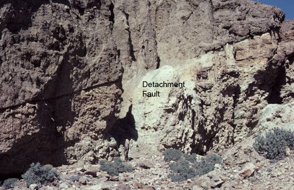
Detachment Fault
BW1. Location/Access: (36o 02.757’N, 116o 45.636’W) 10.2 miles north of Ashford Mill and 16.5 miles south of Badwater. Although this site is located within yards of the main highway, there are no signs, parking areas or other hints of its location. There is a yellow “curve” sign northbound on the highway just north of this location. The detachment fault is in a very small side canyon out of which comes a very small faulted alluvial fan. This is just north of a place where the highway practically reaches the near-vertical front of the Black Mountains.Best Time: Afternoon, all year.
Geology: This small, west-dipping fault is probably not a major detachment surface but is more likely a small sympathetic fault sub-parallel or listric to a major detachment surface related to the Mormon Point turtleback. Once in the canyon, the low angle of the fault, slickensided surfaces and contrasting rock types in the upper and lower plate make it obvious that a detachment-style of motion created the fault. Neither of the rocks exposed above or below the surface represents bedrock in the area and they both appear to be Quaternary deposits that have been offset along this small fault. For over 20 years there has been a debate as to whether these small and the large detachments (such as visible at Site BW2) are active or not; or whether or not these angles represent the angle at the time of motion (Hayman, et. al., 2003). Many have suggested that as the Black Mountain front rose, the inactive fault surfaces rolled back from more vertical active faults located more towards the mountain front. This last hypothesis seems tenable from the data at this location because as you return to the canyon mouth, you will notice that there is a vertical fault scarp in very recent gravel deposits striking parallel to the mountain front as one descends to the highway. If one could excavate the fan gravels to see the cross-cutting relationship between the two faults, this relationship would be clearer. When visiting this area in the late afternoon, as one looks west across the valley, on can see Pleistocene lake shorelines on the bajada surfaces coming down from the Warm Springs Canyon area. The oldest fan surfaces on the Warm Springs Canyon alluvial fan were likely deposited between 860,000 and 390,000 years ago and the youngest deposits are probably between 60,000 and 240,000 years ago (Duhnforth, et.al., 2007). This is also a good location to view the southern end of the Death Valley playa.